
Understanding how pressure differences control wind
Wind is fundamentally driven by differences in atmospheric pressure. The pressure gradient describes how rapidly pressure changes over a given horizontal distance. For mariners, understanding the pressure gradient is essential because the spacing of isobars on a weather chart gives a quick indication of the expected wind strength.
1. What is Pressure Gradient?
The pressure gradient is the change in atmospheric pressure over a specified distance. On a synoptic weather chart, this distance is measured perpendicular to the isobars.
- Closely spaced isobars indicate a steep pressure gradient.
- A steep pressure gradient produces stronger winds.
- Widely spaced isobars indicate a weak or slack pressure gradient.
- A weak pressure gradient generally produces lighter winds.
Therefore, when examining a weather chart, isobar spacing is one of the quickest visual indicators of wind strength.
Remember: Closer isobars → Stronger pressure gradient → Stronger wind
2. Geostrophic Wind Speed
The geostrophic wind is an idealised wind that results from a balance between the pressure-gradient force and the Coriolis force.
Geostrophic wind speed can be estimated using a geostrophic wind scale provided with some synoptic weather charts or available as a transparent plotting scale.
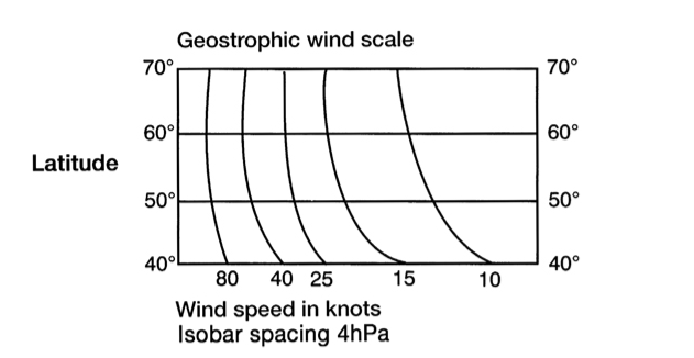
How to use the scale
- Measure the perpendicular distance between two isobars.
- Place this distance against the appropriate latitude on the scale.
- Read the corresponding wind speed from the curved lines.
- The result gives an approximate geostrophic wind speed in knots.
The same isobar spacing can produce different wind speeds at different latitudes because the effect of the Coriolis force changes with latitude.
3. Gradient Wind
In the real atmosphere, isobars are often curved rather than straight. Wind flowing around these curved pressure systems is known as gradient wind.
For air to follow a curved path, the pressure-gradient force and Coriolis force are not the only considerations. The curvature of the flow introduces an additional effect associated with the turning of the air.
As a result:
- Around a low-pressure system, gradient wind speed is generally less than the geostrophic wind speed.
- Around a high-pressure system, gradient wind speed is generally greater than the geostrophic wind speed.
This is particularly important when assessing wind conditions around strongly developed highs and lows.
4. Surface Wind Direction
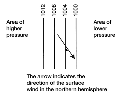
The wind near the Earth’s surface does not normally flow exactly parallel to the isobars.
This is mainly because of surface friction, which slows the wind and changes its direction.
Over the sea, the angle between the surface wind and the isobars is generally around 10°–15°.
In the Northern Hemisphere:
- Surface wind crosses the isobars at a small angle.
- It flows from higher pressure towards lower pressure.
- The wind direction is therefore slightly across the isobars rather than exactly along them.
This provides a useful practical rule when interpreting surface pressure charts.
For the Northern Hemisphere: Surface wind = approximately parallel to isobars + 10°–15° crossing towards lower pressure.
5. Diurnal Variation of Wind Speed at the Surface
Wind speed at the surface can change during the day and night because of changes in convection and atmospheric turbulence.
During the day
Solar heating increases convection and turbulence near the surface. This turbulence mixes air from higher levels downward, where stronger winds may exist.
As a result, the effect of surface friction is distributed through a deeper layer and the reduction in surface wind speed is generally less pronounced.
At night
After sunset, surface cooling reduces convection and the turbulent layer becomes shallower.
The surface wind is then more strongly affected by friction, so wind speed near the surface can decrease.
Over open sea, however, the daily variation in wind speed is generally much smaller than over land because the sea surface temperature changes relatively slowly.
6. Effect of Surface Temperature on Pressure
Surface temperature has an important influence on atmospheric pressure.
Warm surface
When the Earth’s surface becomes strongly heated:
- The air above it becomes warmer.
- Warm air expands and becomes less dense.
- The heated air tends to rise.
- This can contribute to lower surface pressure.
Cold surface
When the surface becomes strongly cooled:
- The air above it becomes colder.
- Cold air becomes denser and tends to sink.
- This can contribute to higher surface pressure.
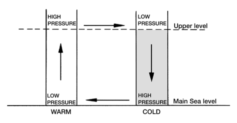
This temperature-pressure relationship is particularly important over large continental areas.
During summer, extensive land areas can become strongly heated and may develop relatively low surface pressure.
During winter, the same regions can become intensely cold, allowing dense air to accumulate and producing relatively high surface pressure.
This seasonal contrast is one of the important physical mechanisms behind large-scale monsoon circulation.
Takeaways
✓ Closely packed isobars = stronger pressure gradient and stronger winds.
✓ Widely spaced isobars = weaker pressure gradient and lighter winds.
✓ Use the geostrophic wind scale to estimate wind speed from isobar spacing and latitude.
✓ Gradient wind accounts for the curvature of the isobars around highs and lows.
✓ Near the sea surface, wind generally crosses the isobars by about 10°–15° towards lower pressure.
✓ Surface wind can vary between day and night because of changes in turbulence and friction.
✓ Warm land tends to favour lower pressure; cold land tends to favour higher pressure.
Before assessing wind strength from a synoptic chart, look at the isobar spacing first. Then consider latitude, pressure-system curvature, surface friction and local temperature effects.