
Understanding how air behaves as it rises and sinks is one of the foundations of meteorology. These simple atmospheric processes determine cloud formation, rainfall, fog, thunderstorms, visibility, and overall weather conditions that mariners encounter at sea. A clear understanding of adiabatic processes also helps officers interpret weather charts and make better navigational decisions.
1. ADIABATIC CHANGES
An adiabatic change occurs when an air parcel changes its temperature without gaining or losing heat from its surroundings. Instead, the temperature changes because of changes in atmospheric pressure.
As air rises, the surrounding pressure decreases, allowing the air to expand. Expansion requires energy, causing the air to cool.
As air descends, atmospheric pressure increases, compressing the air. Compression increases the air’s temperature.
2. ADIABATIC PROCESSES IN THE ATMOSPHERE
The atmosphere naturally follows the same principle.
When warm air near the Earth’s surface rises, it encounters progressively lower atmospheric pressure. As a result, it expands and cools naturally.
Conversely, sinking air moves into regions of higher pressure where it is compressed and becomes warmer.
These continuous rising and sinking motions play a major role in:
✔ Cloud development
✔ Rainfall formation
✔ Thunderstorm growth
✔ Atmospheric stability
Since no heat is exchanged with the surrounding air during these vertical movements, the process remains adiabatic.
3. CLOUD FORMATION
Clouds form through a simple sequence of atmospheric events.
Step 1 – Rising Air
Unsaturated air begins to rise due to heating, terrain, or weather systems. As it rises, it expands and cools.
Step 2 – Condensation Level
If the air continues rising, its temperature eventually falls to the dew point. At this level, the air becomes saturated and water vapour begins condensing into tiny water droplets.
This height is known as the Condensation Level, which generally marks the base of the cloud.
Step 3 – Cloud Growth
Continued upward movement produces more condensation, allowing clouds to develop vertically.
Depending on the temperature:
- Water droplets form in warmer conditions.
- Ice crystals form at colder temperatures.
Remember
✔ Moist air usually produces lower cloud bases.
✔ Dry air generally produces higher cloud bases.
4. ADIABATIC LAPSE RATES
A lapse rate describes how rapidly air temperature changes with altitude.
Dry Adiabatic Lapse Rate (DALR)
When the rising air is unsaturated, it cools at approximately:
1°C per 100 metres (or about 10°C per kilometre)
This cooling rate remains nearly constant until condensation begins.
Saturated Adiabatic Lapse Rate (SALR)
Once condensation starts, latent heat is released into the surrounding air.
This released heat partially offsets the cooling caused by expansion, so saturated air cools more slowly.
Near the Earth’s surface, the average cooling rate is approximately:
0.5°C per 100 metres (or about 5°C per kilometre)
The exact rate varies depending on moisture content and temperature, but it always remains less than the Dry Adiabatic Lapse Rate.
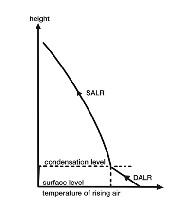
Why is SALR lower than DALR?
Because condensation releases latent heat, reducing the overall rate of cooling.
5. ENVIRONMENTAL LAPSE RATE (ELR)
Unlike DALR and SALR, which describe the temperature of a moving air parcel, the Environmental Lapse Rate (ELR) describes how the actual surrounding atmosphere changes with height.
On average, the ELR is about:
0.6°C per 100 metres (or about 6.5°C per kilometre)
However, this value changes continuously depending on location, season, time of day, and weather systems.
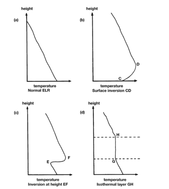
The four common atmospheric temperature profiles are shown in the accompanying illustration.
(A) Normal Environmental Lapse Rate
Temperature steadily decreases with altitude.
This represents the most common atmospheric condition and generally supports normal weather development.
(B) Surface Inversion
Temperature increases with height close to the Earth’s surface.
Common causes include:
- Night-time cooling of land
- Cold sea surfaces
- Calm weather conditions
Surface inversions often trap moisture, smoke, haze, and fog near the ground.
(C) Inversion at Height
A warmer layer of air exists above cooler air.
This often forms when dry air sinks from higher levels and warms through compression.
Such inversions can suppress cloud growth and limit vertical air movement.
(D) Isothermal Layer
Temperature remains nearly constant through a layer of the atmosphere.
These layers reduce vertical mixing and can significantly influence cloud development and atmospheric stability.
Key Takeaways
✔ Air cools as it rises because it expands in lower pressure.
✔ Air warms as it sinks because it is compressed by higher pressure.
✔ Clouds begin forming when rising air cools to its dew point and reaches the condensation level.
✔ Unsaturated air cools faster than saturated air because condensation releases latent heat.
✔ The Environmental Lapse Rate determines atmospheric stability and strongly influences cloud formation, visibility, precipitation, and weather patterns.
Mariner’s Note
Understanding adiabatic processes and lapse rates allows bridge officers to better interpret cloud development, anticipate weather changes, assess atmospheric stability, and make safer navigational decisions. Even a quick observation of cloud type and vertical development can provide valuable clues about the weather ahead.
Stay Observant. Think Weather. Sail Safe.