
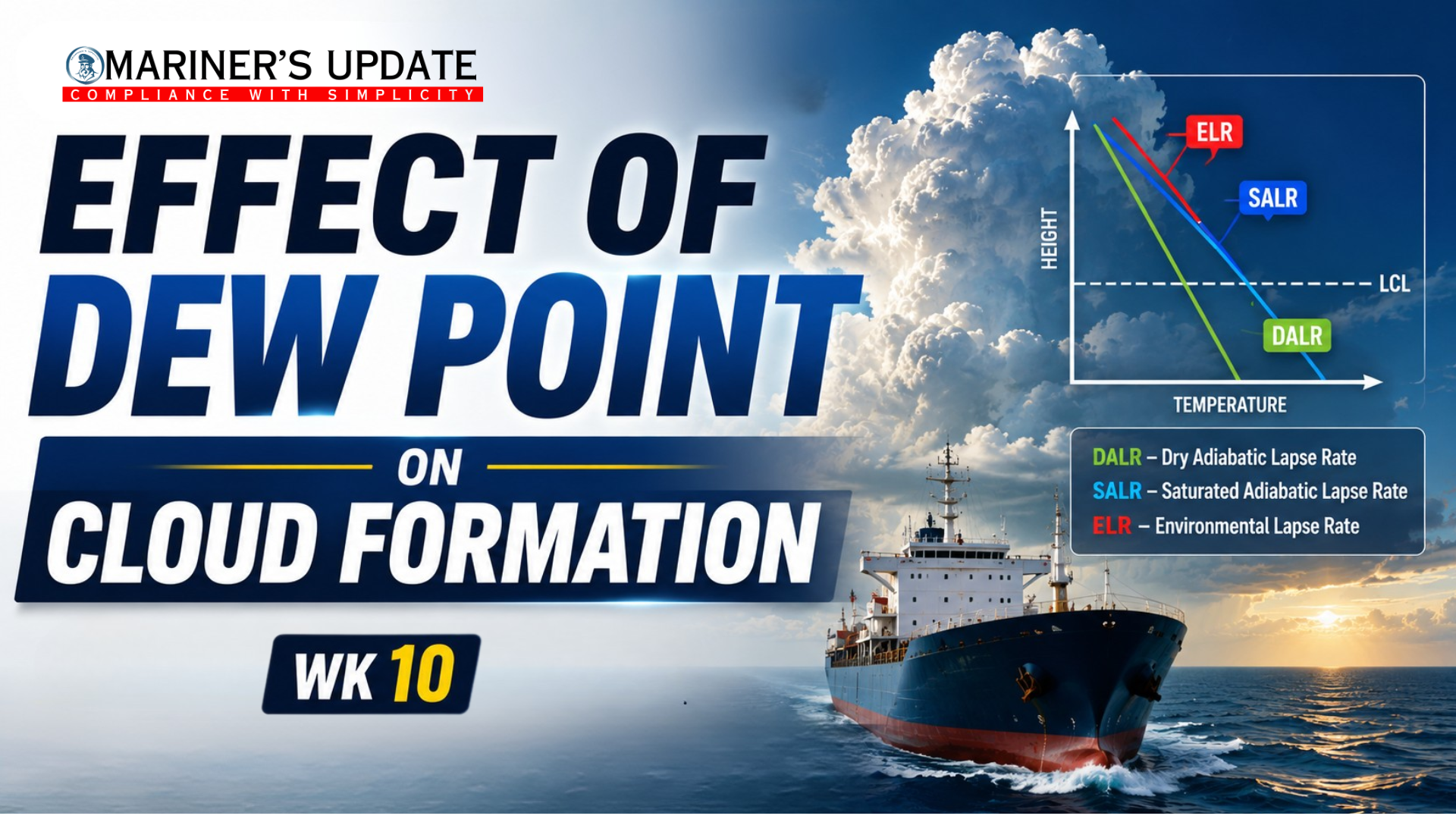
Understanding the relationship between air temperature and dew point is one of the simplest ways to predict cloud development and atmospheric stability. As air rises, it expands and cools. When it cools to its dew point temperature, water vapour condenses into tiny water droplets, forming the base of a cloud. The closer the air temperature is to the dew point, the sooner condensation occurs and the easier it is for clouds to develop.
1. What Controls Cloud Formation?
Three important factors determine whether clouds will form:
- Air Temperature (T): Decreases as air rises due to expansion.
- Dew Point (D): The temperature at which air becomes saturated and condensation begins.
- Lifting Condensation Level (LCL): The height where rising air first reaches its dew point, forming the cloud base.
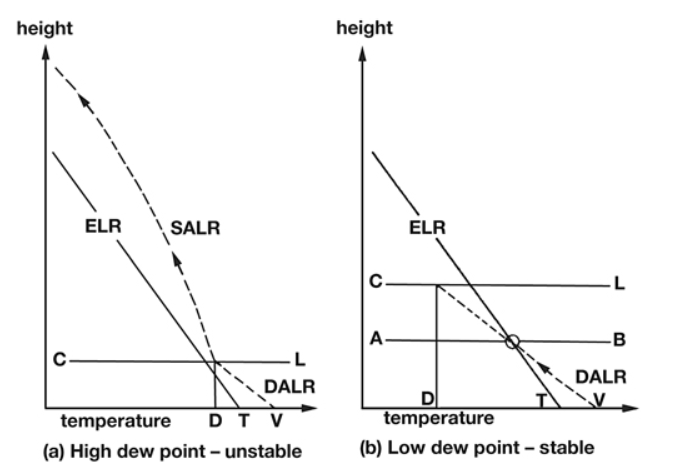
Once condensation begins, the rising air cools more slowly because latent heat is released. This change in cooling rate has a major influence on whether the cloud continues growing or stops developing.
2. Understanding DALR, SALR and ELR
Cloud development depends on comparing three lapse rates:
Dry Adiabatic Lapse Rate (DALR)
- Applies to unsaturated (dry) rising air before cloud formation.
- Air cools rapidly at approximately 10°C per kilometre.
Saturated Adiabatic Lapse Rate (SALR)
- Applies after condensation begins.
- Cooling slows to about 4–7°C per kilometre because latent heat released during condensation partially offsets the cooling.
- This slower cooling often allows moist air to remain warmer than its surroundings and continue rising.
Environmental Lapse Rate (ELR)
- Represents the actual rate at which atmospheric temperature decreases with height.
- Comparing the ELR with DALR and SALR determines whether the atmosphere is stable or unstable.
3. How Dew Point Affects Cloud Development
a) High Dew Point – Moist Atmosphere
When the dew point is close to the air temperature:
- Saturation is reached quickly.
- Cloud base forms at a relatively low altitude.
- Condensation releases latent heat, reducing the cooling rate from DALR to SALR.
- Even gentle lifting can produce clouds.
Typical weather:
- Low cloud bases
- Fog or mist
- Reduced visibility
- Greater potential for showers or thunderstorms
b) Unstable Atmosphere
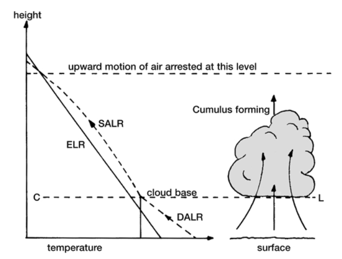
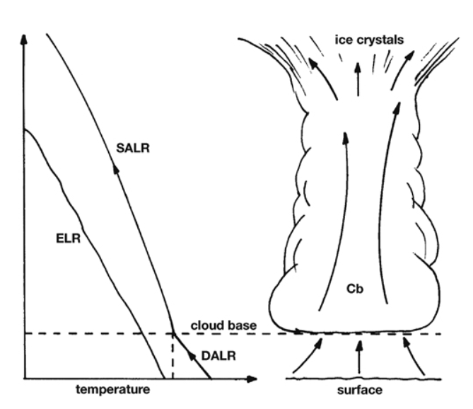
If the SALR remains lower than the ELR, the rising air stays warmer than the surrounding environment.
As a result:
- Air continues to rise.
- Strong vertical currents develop.
- Clouds grow rapidly into towering cumulus or cumulonimbus.
- Heavy rain, thunderstorms and squalls become more likely.
c) Stable Atmosphere
If the rising saturated air becomes cooler than the surrounding atmosphere:
- Upward motion slows or stops.
- Vertical development is limited.
- Clouds spread horizontally instead of growing upward.
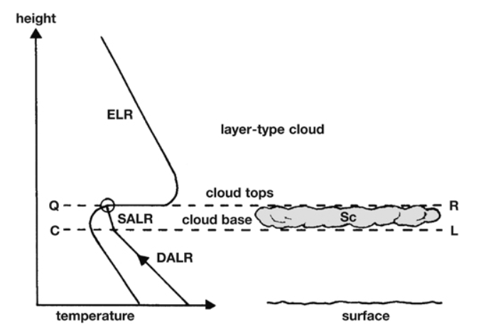
Typical cloud types include:
- Stratus
- Stratocumulus
- Layer clouds associated with steady weather
4. Low Dew Point – Dry Atmosphere
When the dew point is much lower than the air temperature:
- Rising air must travel much higher before reaching saturation.
- Cloud formation may be delayed or may not occur at all.
- The atmosphere generally remains more stable.
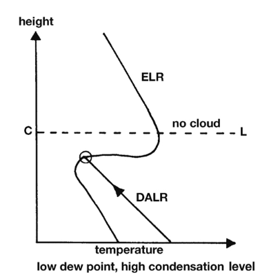
Typical weather:
- Higher cloud bases
- Thin or scattered clouds
- Better visibility
- Clear skies are more likely
5. Practical Weather Interpretation
For mariners, monitoring the temperature–dew point spread provides valuable insight into expected weather conditions.
- Small temperature–dew point difference: Indicates moist air, low cloud bases, fog potential and an increased chance of unstable weather.
- Large temperature–dew point difference: Indicates drier air, higher cloud bases, better visibility and generally more stable conditions.
Remember that the dew point alone does not determine cloud type. The final cloud development depends on the combined effect of dew point, atmospheric stability, and the relationship between the Environmental Lapse Rate (ELR), Dry Adiabatic Lapse Rate (DALR), and Saturated Adiabatic Lapse Rate (SALR).
Key Takeaways
✔ Clouds begin to form when rising air cools to its dew point.
✔ A high dew point produces a lower cloud base and increases the likelihood of cloud formation.
✔ A low dew point results in a higher condensation level and fewer clouds.
✔ DALR governs cooling before condensation, while SALR governs cooling after condensation begins.
✔ Comparing ELR, DALR and SALR determines whether the atmosphere is stable or unstable.
✔ Understanding dew point and lapse rates helps mariners anticipate fog, low cloud, visibility changes, showers and thunderstorm development, making it an essential tool for safe voyage planning.