Understanding Visibility, Fog Formation & Its Importance to the Mariner
Visibility is one of the most important weather factors affecting safe navigation. A reduction in visibility can significantly increase the risk of collision, particularly when navigating in areas of heavy traffic, coastal waters, narrow channels or during pilotage.
For the bridge team, understanding why visibility deteriorates, how fog develops, and what weather conditions favour its formation helps the Master make better and earlier navigational decisions.
1. WHAT IS VISIBILITY?
Visibility may be understood as the maximum distance at which an object can be clearly seen and identified.
Poor visibility is generally caused by material present in the atmosphere, mainly:
- Water droplets suspended in the air, producing mist or fog.
- Solid particles such as dust, smoke, sea salt or sand.
Good visibility is generally favoured when the air is well mixed and strong winds help prevent the accumulation of moisture and suspended particles near the surface.
For the mariner, visibility should never be considered only as a reported weather value. Its trend is equally important. A gradual fall in visibility may provide an early indication that fog or another form of atmospheric obscuration is developing.
2. MIST, HAZE & FOG – KNOW THE DIFFERENCE
MIST
Mist is used when horizontal visibility is approximately 1,000–2,000 metres and the reduced visibility is caused by moisture in the air.
Mist is associated with a high relative humidity, generally above 95%.
HAZE
Haze occurs when visibility is reduced by dry particles such as:
- Dust
- Smoke
- Sand
- Industrial pollutants
- Particles carried from land
For ships operating near desert regions, dust and sand carried offshore can cause significant visibility reduction.
FOG
Fog is present when horizontal visibility falls below 1,000 metres, irrespective of the exact cause.
For a navigating bridge, this is an important threshold because the reduction in visual range can occur rapidly and may substantially change the risk picture around the vessel.
3. HOW DOES FOG FORM?
Fog develops when a large volume of air is cooled to its dew point.
As the air cools, it can no longer retain the same amount of water vapour. Condensation then occurs and tiny water droplets form close to the sea or land surface.
The cooling required for fog formation can occur through:
- Contact with a colder land or sea surface.
- Turbulent mixing of different layers of air.
- Evaporation of water into colder air in certain situations.
The important principle for the mariner is simple:
Warm, moist air + sufficient cooling → air reaches dew point → condensation → fog.
4. MAIN TYPES OF FOG
The principal types of fog most relevant to the mariner are:
- Advection or Sea Fog
- Frontal or Mixing Fog
- Radiation Fog
- Arctic Sea Smoke
Each type develops under different atmospheric and surface conditions.
5. ADVECTION OR SEA FOG
Advection fog is one of the most important types of fog encountered at sea.
It forms when relatively warm, moist air moves over a colder sea surface. The air is cooled from below until its temperature reaches the dew point, resulting in condensation and fog formation.
Conditions that favour advection fog:
- Warm and moist air.
- A colder sea surface.
- Air temperature approaching the dew point.
- Moderate wind, commonly around 4–16 knots.
- Continued movement of moist air over the colder water.
Because sea surface temperature changes relatively slowly in the open ocean, areas with persistent temperature contrasts can experience advection fog repeatedly.
Important examples
Advection fog is well known in areas such as the Grand Banks of Newfoundland, where warm moist air encounters the colder Labrador Current.
The English Channel can also experience advection fog, particularly when south-westerly air reaches the British Isles during spring and early summer.
Practical point for the bridge
When planning a passage, the Master can assess the likelihood of fog by comparing:
Air temperature + Dew point + Wind direction + Sea temperature + Expected weather ahead
A falling difference between air temperature and dew point should increase awareness of possible visibility deterioration.
6. FRONTAL OR MIXING FOG
Frontal fog can develop near the boundary between two significantly different air masses.
It is commonly associated with a warm front or warm occlusion, where relatively cold air meets warm, moist air.
Rain or drizzle falling through the colder air can evaporate and add moisture to the atmosphere. This process can cool the surrounding air and contribute to saturation and fog formation.
Key features:
- Associated with frontal systems.
- Often occurs in temperate and higher latitudes.
- Warm, moist air interacts with colder air.
- Rain or drizzle can contribute to the development of fog.
- Visibility may deteriorate rapidly near the frontal boundary.
For the bridge team, frontal weather should therefore be treated as a potential visibility hazard, particularly when rain, drizzle and low cloud are already present.
7. RADIATION FOG
Radiation fog normally forms over land, rather than over the sea.
It is most common during autumn and winter, particularly during clear and relatively calm nights.
At night, the land loses heat through radiation. The air immediately above the surface is then cooled. If the temperature falls to or below the dew point, condensation occurs and fog forms close to the ground.
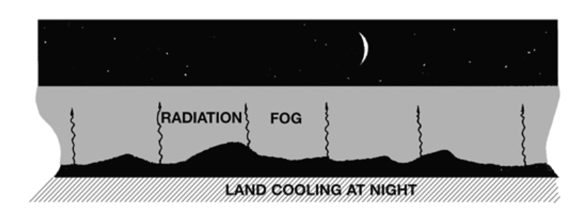
A gentle breeze can provide limited turbulent mixing and help fog develop close to the surface. Stronger winds, however, tend to mix the cooling air through a deeper layer and may prevent the air from reaching saturation.
Typical conditions:
- Clear skies.
- Light winds.
- Long periods of overnight cooling.
- Damp or low-lying ground.
- Air temperature falling to the dew point.
Radiation fog is normally densest around sunrise and tends to disperse relatively quickly once the land begins to warm.
Although it does not normally form over the sea, it can move offshore from the land, sometimes affecting coastal navigation.
8. ARCTIC SEA SMOKE
Arctic sea smoke is a special form of fog-like condensation that develops when very cold, dry air moves over relatively warm water.
The large temperature difference between the sea surface and the air causes rapid evaporation from the water. The added moisture then condenses in the very cold air close to the sea surface.
The result can appear like smoke or steam rising from the sea.
The source material notes that this condition generally requires the air to be approximately 9°C or more colder than the sea surface.
It is particularly associated with:
- Arctic and Antarctic waters.
- The Baltic.
- Cold-air outbreaks over relatively warm water.
- Some eastern continental coastal waters during winter.
Unlike many other fog situations, Arctic sea smoke can occur even with strong winds, because the continuous supply of cold air maintains the process.
9. MIST, DUST & HAZE – A MARINER’S CONCERN
Visibility reduction is not always caused by fog.
Dust and sand can travel considerable distances offshore. Sandstorms associated with desert regions can extend up to about 160 km (100 miles) out to sea.
This can become a serious operational problem because the vessel may experience significant reduction in visual range even when no fog is present.
Areas influenced by seasonal winds from desert regions therefore deserve particular attention when planning coastal passages.
10. FOG & SOUND SIGNALS
Fog can also affect the way sound is perceived.
The atmospheric conditions associated with fog may cause distortions in:
- The apparent direction of a sound.
- The apparent strength of a sound signal.
- The perceived distance from the sound source.
Therefore, a watchkeeper should exercise considerable caution when attempting to determine the direction or distance of another vessel solely from a fog signal.
Sound signals should be considered together with all other available navigational information.
11. RADAR PERFORMANCE IN LOW VISIBILITY
Radar remains an essential navigational aid during restricted visibility, but atmospheric conditions can influence its expected performance.
Changes in humidity with height can produce atmospheric refraction effects:
- Super-refraction may increase radar range.
- Sub-refraction may reduce radar range.
Heavy rain can have a greater adverse effect on radar performance than fog itself.
Therefore, radar information should always be interpreted carefully and in conjunction with:
- Visual observations, when available.
- AIS information.
- Sound signals.
- Radar plotting and target assessment.
- Proper lookout.
- Other bridge navigational systems.
12. MASTER’S WEATHER DESK – PRACTICAL TAKEAWAY
When visibility is expected to deteriorate, the bridge team should think ahead of the fog, not only react after it arrives.
Keep an eye on:
✓ Air temperature
✓ Dew point and the temperature/dew-point spread
✓ Sea surface temperature
✓ Wind direction and speed
✓ Frontal systems
✓ Rain and drizzle
✓ Coastal weather conditions
✓ Visibility trends along the route
When visibility starts falling:
✓ Increase the level of bridge team awareness.
✓ Make effective use of radar and AIS.
✓ Maintain an effective lookout.
✓ Pay close attention to sound signals.
✓ Consider the vessel’s speed and traffic situation.
✓ Anticipate further deterioration rather than waiting for visibility to become very poor.
MASTER’S NOTE
Fog rarely becomes a navigation problem without giving some warning.
A careful Master watches the relationship between temperature, dew point, sea temperature, wind and weather systems and uses these signs to anticipate deterioration in visibility.
Good weather awareness gives the bridge team more time to prepare, assess risk and take appropriate action.