Clouds are much more than attractive formations in the sky—they are one of nature’s most reliable indicators of changing weather. Long before the advent of satellites, radar, and sophisticated forecasting models, mariners relied on cloud observations to anticipate approaching weather systems. Even today, cloud recognition remains an essential skill for every bridge watchkeeper.
By understanding cloud types, their height, appearance, and development, seafarers can identify signs of improving or deteriorating weather, verify forecast information, and make informed navigational decisions. A careful observation of the sky, combined with wind direction, barometric pressure, sea state, and visibility, provides valuable insight into the weather that may develop over the coming hours.
How Clouds Are Classified
The World Meteorological Organization (WMO) classifies clouds into four main groups based on the height of their bases and their vertical development. Each group is associated with particular atmospheric conditions and can provide useful clues about the weather ahead.
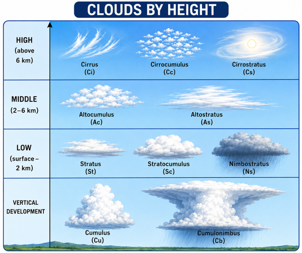
High-Level Clouds (Above 5,500 m)
Cirrus (Ci), Cirrostratus (Cs) and Cirrocumulus (Cc)
High clouds consist mainly of ice crystals due to the extremely low temperatures at high altitudes. They appear thin, white and delicate, often resembling feathers or fine streaks across the sky.
Although they rarely produce precipitation that reaches the surface, they frequently act as the first warning of an approaching warm front, tropical disturbance or low-pressure system. Increasing coverage of high clouds often signals a change in weather within the next 24–48 hours.
Middle-Level Clouds (2,000–5,500 m)
Altostratus (As) and Altocumulus (Ac)
These clouds occupy the middle levels of the atmosphere and usually indicate increasing moisture.
- Altostratus appears as a grey or bluish sheet covering much of the sky. As it thickens, steady rain or snow often follows.
- Altocumulus forms as white or grey patches or rolls. While it may occur in fair weather, increasing Altocumulus—especially on warm, humid days—can indicate atmospheric instability and the possibility of showers or thunderstorms later.
Low-Level Clouds (Surface–2,000 m)
Stratus (St), Stratocumulus (Sc) and Nimbostratus (Ns)
These clouds generally have a greater influence on visibility and precipitation.
- Stratus forms as a uniform grey layer and is commonly associated with mist, drizzle and poor visibility.
- Stratocumulus appears as low, lumpy cloud layers. It often brings stable weather with occasional light drizzle.
- Nimbostratus is a thick, dark rain cloud producing widespread and prolonged precipitation, frequently accompanied by reduced visibility and gloomy conditions.
Clouds with Vertical Development
Cumulus (Cu) and Cumulonimbus (Cb)
These clouds develop vertically due to strong convection.
- Small Cumulus clouds are generally known as “fair-weather clouds” and indicate localized upward air movement.
- When atmospheric instability increases, they can grow into Cumulonimbus, the largest and most powerful cloud type.
Cumulonimbus clouds are capable of producing:
- Heavy rain
- Thunderstorms
- Lightning
- Hail
- Strong gusts and squalls
- Severe turbulence
- Waterspouts or tornadoes in favourable conditions
For mariners, the appearance of towering Cumulonimbus clouds demands increased vigilance and continuous monitoring of weather conditions.
What Different Clouds Tell Us
Every cloud tells a story about the atmosphere. Learning to interpret these signs allows mariners to anticipate weather changes before they occur.
Cirrus (Ci)
Often the earliest indication of an approaching weather system. A gradual increase usually suggests deteriorating weather or an approaching depression.
Cirrostratus (Cs)
A thin veil covering much of the sky, often producing a halo around the Sun or Moon. It frequently precedes widespread rain by several hours.
Cirrocumulus (Cc)
Small rippled cloudlets that usually indicate fair weather but may also appear before changing weather patterns.
Altostratus (As)
A thickening Altostratus layer often signals continuous rainfall within the next 12–24 hours.
Altocumulus (Ac)
May indicate increasing instability. If the clouds become more numerous or develop vertically, showers or thunderstorms become more likely.
Stratus (St)
Associated with stable air, poor visibility, mist and light drizzle.
Stratocumulus (Sc)
Normally indicates settled conditions with little rainfall, although light drizzle may occasionally occur.
Nimbostratus (Ns)
The classic rain cloud, bringing prolonged rain, low cloud base and poor visibility over a wide area.
Cumulus (Cu)
Small clouds indicate fair weather. Rapid vertical growth suggests strengthening convection and possible showers.
Cumulonimbus (Cb)
A clear warning of severe weather, including thunderstorms, lightning, heavy rain, strong gusts and squalls. Safe navigation requires careful monitoring whenever these clouds are nearby.
Practical Tips for Seafarers
✔️ Observe cloud type, height, shape and movement during every bridge watch.
✔️ Compare cloud development with barometric pressure trends, wind direction and visibility.
✔️ Monitor whether clouds are increasing, thickening or building vertically, as these changes often indicate worsening weather.
✔️ Record cloud observations accurately in routine weather reports and bridge logbooks.
✔️ Use cloud observations together with weather forecasts, synoptic charts and onboard instruments rather than relying on a single source of information.
✔️ Always remain alert when rapidly developing Cumulus or Cumulonimbus clouds are observed, especially in tropical and coastal regions where weather can change quickly.
Takeaway
The sky provides one of the earliest and most valuable sources of weather information available to every mariner. Recognizing cloud types and understanding what they signify enables officers to anticipate changing conditions, validate weather forecasts, and make safer operational decisions.
Developing strong cloud observation skills is a simple habit that can improve situational awareness, enhance bridge resource management, and ultimately contribute to safer navigation at sea.